組織対応ソフト ジョイント防災
by 株式会社フロムハート
🗂️ Tools
Features 組織対応ソフト ジョイント防災
A collaboration between PC software with a "simultaneous safety confirmation and notification tool" function and a personal disaster prevention application that "delivers life-saving information".
It is a fusion software that protects the lives and livelihoods of organization members.
☆ The functions that can be sent from the computer to the app are as follows."Simultaneous safety confirmation""Simultaneous safety confirmation" can be used for individual members and for all members from the organization."Notification Tool"You can send messages from your organization to all members at once.Enter the user number registered in the application into the PC software and link the web and the application via the server.
It cannot be used unless the user number is entered into the PC software.
☆ This app implements personal functions.〖the purpose〗A completely new type of disaster prevention app that challenges "Delivering information that can save your life!" When an earthquake occurs, the app automatically starts up and automatically displays the route to the nearest evacuation site wherever you are in the country.〖Motivation for production〗There are three main types of information in the disaster prevention app.
☆ Preliminary learning: You can obtain information such as the expected damage situation in the area (area) such as hazard maps, evacuation sites, tsunami evacuation facilities, and shelters.
Improve disaster prevention awareness and acquire disaster prevention knowledge.
☆Earthquake occurrence notification: Notification of an emergency earthquake early warning from the Japan Meteorological Business Support Center.
We will promptly inform the area of the occurrence of an earthquake and encourage the initial response.
☆Post-disaster information…Information useful for disaster-affected life, such as information on the establishment of evacuation shelters, will be posted.However, todays disaster prevention apps do not have personal (personal) information about each of us.And at the moment of the earthquake, they do not inform us of "the nearest evacuation site"!I studied the hazard map around my house!
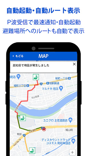
I even remembered my place of work and school!However, if you encounter an earthquake while commuting to work or school, when you are on the road for work, or when you go shopping in the city...There is no information on the disaster prevention app of the municipality once it goes out of the municipality area.This is how the disaster prevention app "Evacuation Route Navi Mirai" for individuals, "Save lives from earthquakes!" was born.With this "Save lives from earthquakes!" function, the application will automatically start when an earthquake early warning is issued, and the route to the nearest evacuation site anywhere in the country will be automatically displayed.(1) Automatic startup/automatic evacuation route displayAn earthquake warning alarm will be notified by the Earthquake Early Warning P wave of the Japan Meteorological Business Support Center.At the same time as the earthquake warning alarm, the app automatically starts without any operation, identifies the current location with the GPS function, and automatically displays the route to the nearby evacuation site.By setting reception anywhere in the country, it is easier to take the first action and the possibility of saving lives increases.However, do not move when you are in a safe building with excellent earthquake resistance!
Therefore, it is important to determine the best course of action.In addition, in this application, designated evacuation sites and wide-area evacuation sites are displayed with a single icon.Also, as long as the display screen is not erased, the display can be maintained on the terminal screen even if the communication status deteriorates.This function notifies you of the route to the evacuation site and does not guarantee safe movement.
Please use it while confirming the safety situation.(2) Earthquake early warning receiving location settingYou can set the desired receiving location for Earthquake Early Warning anywhere in Japan.
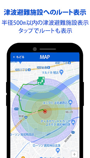
Notifications must be set.③ Route display to tsunami evacuation facilities (buildings)It is used when the terminal owner is in the tsunami area.The concentric circle display with a radius of 500 m makes it easy to understand the distance to the tsunami evacuation facility (building), allowing you to quickly select it.For this function, you need to select the tsunami evacuation facility (building) that you think is most suitable.In addition, this function notifies the location of the tsunami evacuation facility (building) and does not guarantee safe movement.
Please use it while confirming the safety situation.④ Route display to evacuation shelterEvacuation center data is collected directly from the websites of municipalities nationwide to ensure reliability.Since the types and names of evacuation centers differ slightly depending on the municipality, icons are displayed according to the categories of designated evacuation centers, welfare evacuation centers, and temporary accommodation facilities.Evacuation centers may also serve as evacuation sites in some municipalities.In addition, this function will inform you of the location of the evacuation shelter and does not guarantee safe movement.
Please use it while confirming the safety situation.⑤ Route display to home (used when it is difficult to return home)To use it, you need to register "home registration" in the registration menu.It can be used as a countermeasure for people who are unable to return home.You can view the route to your home and follow the route on the map to get home without getting lost.In addition, this function is to inform you of the route to your home, and does not guarantee safe movement.
Please use it while confirming the safety situation.⑥ Nationwide Evacuation Site / Evacuation Center SearchEvacuation sites, tsunami evacuation facilities (buildings), and shelter data are available for about 190,000 places nationwide from Hokkaido to Okinawa.Data is collected directly from the websites of municipalities nationwide to ensure reliability.⑦ Current location mapIt is necessary to turn on the GPS function of the carrier.
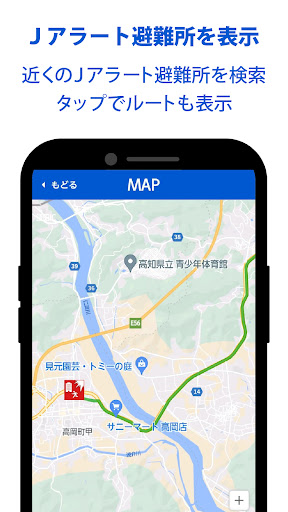
Also, if you select "GPS function ON only at startup" in the GPS function conditions when registering the application, you can not notify the location when the application is not started.⑧ J-alert evacuation center display and route displayWhen J-Alert (National Instant Warning System) is issued, ballistic missile information, earthquake early warnings, large tsunami warnings, and tsunami warnings can be searched for shelters designated by national and local governments.However, please note that data on evacuation sites and shelters such as volcanic warnings, volcanic early warnings, and heavy rain emergency warnings cannot be searched.In addition, this function will inform you of the location and route of the evacuation center, and it does not guarantee safe movement.
It is necessary to use it while confirming the safety situation.⑨ Safety confirmationTo use the service, you need to register the person you want to confirm the safety of, such as a family member, in the "contact information registration".⑩ Location information sharingIn order to use this service, you will need to register your family members and other people with whom you want to share your location information in "Contact Registration".After an earthquake, it may be difficult to search the location of the GPS function depending on the network environment.Please be aware of this before using.⑪ Evacuation Completion Notification to Evacuation CenterTo use this service, you need to register the person you want to notify that evacuation to the evacuation center has been completed in "Contact Registration".
It can only be used when evacuated to the evacuation center of this application data.⑫ Favorite registration (location) setting and route display"Favorite registration" is required for use.You can register any one location on the map, such as your place of work or accommodation at your travel destination.After encountering an earthquake, if you tap the registration icon, the route will be displayed, and you can move without getting lost even in the first place.This function is to inform you of the route to the favorite registration destination, and does not guarantee safe movement.
Please use it while confirming the safety situation.〖Registration Menu〗◎ Registrant informationRegistration is required to use this app.◎ Home registrationWhen it is difficult to return home, the route to your home will be displayed without getting lost.◎ Contact registrationIt is necessary to use the safety confirmation, location information sharing, and evacuation completion notification functions.◎ Favorite registrationYou can register one place of your choice.
Please use it by registering your work place or favorite store.
Social Features
Connect and share with friends and the community.
Gaming Features
Enjoy immersive gaming experience with various game modes.
Weather Features
Get accurate weather forecasts and real-time updates.
See the 組織対応ソフト ジョイント防災 in Action
Get the App Today
Available for Android 8.0 and above